Discover how to harness the potential of drone software development to catapult your company to new heights. At Ways and Means Technology, we specialize in customizing drone app development solutions for businesses in a variety of industries. Join us in unlocking the full potential of drones and revolutionizing the way you operate.
Staying ahead of the curve in today's fast-paced environment is critical. That is why businesses all around the world are embracing the opportunities provided by drone software development. Our expertise in developing cutting-edge drone management software can help you achieve a competitive edge in videography, agribusiness, food, or healthcare. Our economical and tailored solutions provide seamless integration, increased efficiency, and optimal operations.
Drone technology is still evolving, and agriculture drone software development is just one illustration of its transformational impact. We understand the importance of implementing drone management software into your business plan as pioneers in the sector. Allow us to lead you through this exciting adventure, offering you with powerful drone software that is tailored to your specific needs.
Our knowledge extends to drone fleet management, with UAV software development allowing operators to operate many drones for mission-based aerial light shows. We improve O/S flight-based drone show software by incorporating drone swarm simulation programming and controllers for applications and operating systems, resulting in engaging and synchronized drone shows.
With our innovative mapping tools, you can revolutionize agriculture. It converts data into real-time comparative aerial maps, allowing for reverse logic georeferencing and orthomosaic stitching. Farmers can use cloud-based technologies to analyze and store digital photos for successful pest, disease, and weed management on a variety of terrains.
Using our cloud or on-premises solutions, you can efficiently handle drone-captured photos, videos, and data. Our RESTful APIs offer seamless analysis and information sharing with enterprise systems such as ERP, CRM, SCM, and BI platforms via highly scalable multi-server instances, empowering businesses to make educated decisions.
Our skilled software development team is made up of industry-specific technical experts. This enables us to develop customized drone software solutions for the construction, agricultural, land surveying, media, aviation, real estate, mining, forestry, and other drone mapping services industries.
With our cutting-edge operating systems, you can unleash the full potential of UAVs. AI features for collision avoidance, object tracking, precision navigation, and landing calibration are included into our program. We provide a variety of payload integrations, such as RGB, infrared, LiDAR, and radar sensors that are compatible with various UVS models and controllers.
With our drone inspection software, you can efficiently inspect assets in real time. Operators can swiftly assess assets, generate point cloud data sets, and translate findings into CAD and GIS data by combining image optimization tools and machine learning algorithms. Comprehensive reports document anomalies for in-depth investigation.
With our drone photogrammetry software, you can create highly precise geographical mapping. We specialize in converting drone-captured aerial photos and point clouds (including thermography, infrared, and RGB) into orthomosaic maps and 3D digital terrain models. Businesses benefit from precise and detailed mapping data provided by our unique drone surveying solutions.
Control and access to your drone delivery activities are available in real time. Our cloud-connected software delivers real-time flight data and control, assuring efficient navigation while taking no-fly zones, elevation, and obstacle avoidance into account. Manage your entire delivery fleet with a simple web-based interface that allows for seamless and exact landing and distribution.
Stay ahead of the curve with our indoor drone positioning system development. Our software integrates the most recent Indoor Positioning System technology, allowing drones to navigate indoors with precision. We also specialize in 3D positioning systems and offer germicidal C-band ultraviolet (UVC) drone navigation solutions. Our indoor drone software is perfect for hospitals, public transit, schools, and other environments that require disinfection and sanitation.
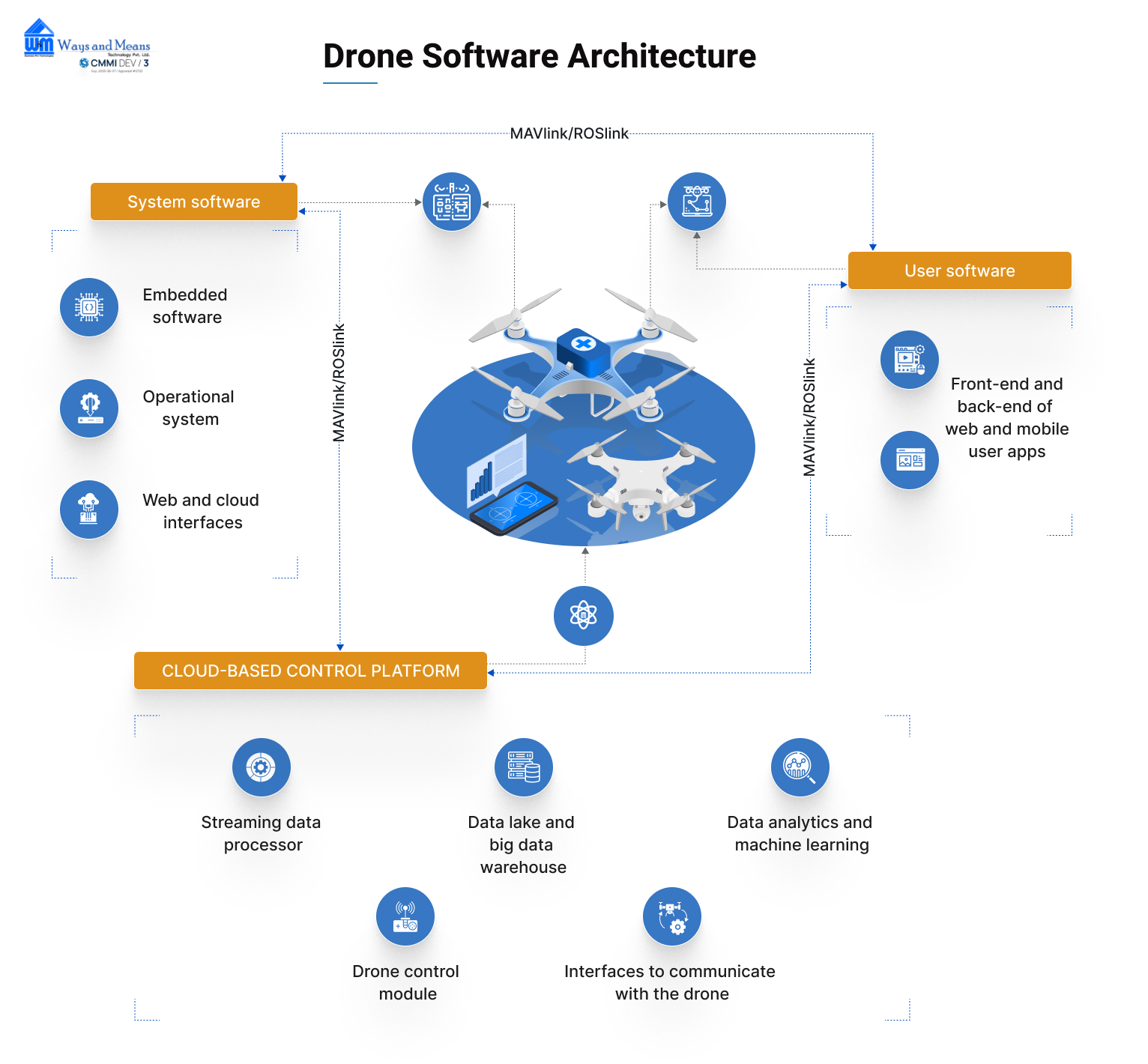
We specialize in creating cutting-edge drone software solutions that are suited to your specific company requirements. Our skilled team of developers and engineers uses drone technology to create customized applications and software platforms. We have the knowledge to create high-quality solutions that improve efficiency, increase production, and drive innovation in your operations, whether you need drone control systems, data analytics, mapping software, or any other drone-related software.
I need this
We offer expert coaching and strategic recommendations to help you make informed decisions about your drone software development projects. We understand the intricacies and difficulties that come with using drone technology into your company processes. Our specialists collaborate with you to assess your needs, discover opportunities, and provide a detailed implementation plan. We provide essential insights and help to guarantee your drone software development activities are a resounding success, from technology selection and architecture design through project management and best practices.
I need this